Google Earth (GE) is an extraordinary application whose features cut across almost every area of digital composition and research. Every topic has some element of geographic location to it. GE may also be the current best example of the power of integrated multimedia as GE's many features stimulate the use of all of the digital palette (Houghton, 2011).
On the one hand Google Earth is a kind of online map reader, a fun, beautiful 3-dimensional map of planet Earth for desktop computers, touch tablets and smart phones. This zoomable geobrowser's easy to use mapping tools enable extensive search, exploration and measurement of what is on the land and under the oceans. Its data is so comprehensive that it is more on the scale of an interactive book or encyclopedia. The developers of Google Earth (GE for short) constantly update its street view photography, satellite and aerial maps and other geographic information yet retain older data for comparison and analysis. This sophisticated application and a significant amount of supporting and extending material are available for free from earth.google.com. On the other hand, Google Earth turns readers into unconventional authors and composers by providing powerful multimedia tools for planning trips, animating a travel sequence, writing and saving annotations and narrations, map creation, making links to Web pages, image posting, recording audio, movie making, story telling and creating 3D models of actual buildings. Creations from GE also integrate well as insertable media into other forms of composition from word processors and video editors to Web pages.
As much of what we learn and make decisions about has a specific location, maps improve our thinking by revealing the relationships of things, especially between a location and its surroundings. Educators extend that relationship to many other areas of content and thought (Jones, 2007; Kerski, 2006; Siegle, 2007). In the 1960's, Geographic Information Systems (GIS) on computers transformed this capacity to think geographically and visually. This thinking capacity expanded to ever more users with the commercialization of GIS applications in the 1980's. GIS application users no longer merely saw a static map, they actively selected the most useful information by adding and subtracting layers of overlapping information from a huge set of data. They became their own map makers by the choices they chose to display. Since 2005, a sub-category of GIS applications called virtual globes or geobrowsers has provided free access to an increasing number of the features and to an increasing portion of the knowledge made available previously by commercial GIS systems. Google Earth is one of these geobrowsers.
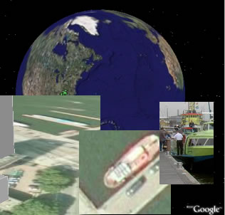
In these geobrowsers, information symbols, markers and pop-up windows are super-imposed on top of two and three-dimensional views of satellite maps. The collage image of the first paragraph is made up of screen shots taken by zooming to different views of a location within Google Earth. Clicking this image activates the download of a file of placemarks, a type of GE file called a KMZ file. Once downloaded, clicking the file in turn launches the application Google Earth and reveals the sites from which the collage was created. The user zooms from space through different altitudes to dockside. Where is it? Can you use clues in this picture to find or get close to this spot before clicking the collage?
These geobrowsers make unprecedented amounts of knowledge available for free to anyone with Internet access. Beyond Google Earth, other geobrowsers include the NASA community's open source and copyright free World Wind, Microsoft's Bing Earth and ESRI's freely and publically available ArcGIS Explorer (Windows only; reviews). Currently best in its class, Google Earth displays spatial information about places on planet Earth. Google Earth and Bing Earth have also developed street shot level views looking horizontally with such accuracy that citizens in various locations worry about their loss of privacy. Google Earth's implementation of this idea is called Street View. This has been extended to hiking trails. In 2011 Google began mapping inside buildings, what GE is labeling Indoor Maps. Tens of thousands of inside maps have become available, from businesses to airports. Dozens of competitors are now vying for the indoor mapping software market.
This concept of geobrowser has been expanded in many directions: underwater in the Google Earth oceans and selected lakes; and off-planet with Google Moon; and Google Mars. This extends to the universe with Google Sky and WorldWide Telescope. Need to learn or teach some astronomy? These applications are incredible tools for such purposes. The capacity of virtual globes to inform and enrich is so great that understanding and using them should be a literacy requirement supported by school curriculum for all citizens.
Street View
The Street View concept was initially developed for just a few cities, some 50 locations by 2008, but the international Street View list has been constantly expanding. Google keeps a constantly expanding map of the countries where its street capture vans have done their work.
Viewers can click down a street or location arrow by arrow or rotate the picture 360 degrees at any point or zoom in further. Google's Street View tutorial movie of how this works is funny and informative. Google keeps a working page of the most current list of cities that have Street View, as well as which cities they are working on next. As an example, click this link, location in downtown Tokyo, Japan, to dynamically follow the links in this location to try out other views and locations.
Indoor Maps
Google's Indoor Maps are just an extension of Google's Street View. However, instead of having the recording cameras on a van driving down the street, the equipment is now in a backpack or cart. Google is keeping a running directory of its indoor maps that includes many countries.
One quick superb example of Indoor Maps can be found by using either Google Maps or Google Earth and visiting the MET's 2 million works of art and more. That is, search for and to go to the Metropolitan Museum of Art in New York using either application. Touring the art museum online in this way can be further assisted by using related online files such as the Museum Map Guide brochure (pdf) and the MET's Family and Children's Guides.
This first graphic on the right shows a screen shot from a search for the MET using Google Maps, with a circle around the area to click in Google Maps to directly enter the Indoor Map for the MET. Once clicked, the user is using Street View commands to move within the MET. Those not familiar with touchpads may prefer to stick with keyboard arrow keys initially for moving around.
The second graphic on the left is a montage of screen displays from Google Earth. The green-bordered box shows the screen before the Street View icon is clicked, though it is circled in this frame. The blue lines overlayed on the MET and surrounding streets show areas where Street View visuals are available when the person icon is touched. The orange bordered view shows what an inside view looks like. Drag that person icon onto the MET building and the interior views begin to appear. Just as with Street View outside buildings, use the commands for moving, rotating and zooming, which are sometimes overlayed and visible on the screen. Use the arrow keys to move around.
In the near future, museums, stores and other institutions will be utilizing Indoor Positioning that will provide step by turn directions to take users to any location and to any object in the museum or other space.
Sidebar Controlling Search, Location and Layers: The Screen Movies
The three major basic skills needed for Google Earth's general use and application to education consist of searching (Search), making and organizing placemarks (Places) and layering information (Layers). Teachers of all content areas will find the virtual globe has numerous implications and applications for teaching and learning. The narrated screen movies below demonstrate the needed knowledge procedures for the three major divisions of Google Earth's sidebar: search, locations and layers.
Search
Search screencast (approximately 2 minutes in length) When the cursor is in the upper right of the Earth display area, navigational controls reveal themselves for moving, tilting, and zooming. One can use navigational controls to wander around the planet zooming in and out of different locations. The search feature in the upper left of the side bar leads to the map jumping quickly to place names and business and organizational names once they are entered. Once a location is found by search or navigation, the Layers feature reveals further information about the area.
Location
Google has already created tens of thousands of placemarks. Creating personal placemarks allow educators and learners to organize and sequence Google Earth's display to accompany lessons, presentation and study. These Placemarks default to being stored on the computer on which they are created, but they can also be saved as files which makes them exportable, web page shareable and mobile to any computer. Placemarks can be stored within the My Places feature of the Google Earth application on a specific computer workstation. Such placemarks in My Places can only be used on that workstation. Right-clicking a placemark creates a file that can be moved from computer to computer, through storage devices or as file attachments for email or instant messenger applications. Placed within folders on the hard drive, the files can be hyperlinked from other applications such as Powerpoint and Excel.
Make Placemarks screencast (approximately 2 minutes in length) Placemarks can be created and labeled in seconds. The description box under the title of the placemark can hold a large quantity of information, and HTML text linking pictures and other media. More importantly they can be grouped into folders within Google Earth or within folders on portable storage media. In short, to save a single placemark, right click one and from the menu choose Save As. To save a set of placemarks as one file, right click on the correct folder in My Places and choose Save As which will make a placemark containing the contents of the entire folder. A text-based tutorial is also available.
Save and Use Placemarks screencast (approximately 2 minutes in length) This screen movie explains how to create folders and organize the placemark files within them. They might be used in science to study Earth's geographic features or ecologies and in political science to study the impact of government decisions on a culture and its land.
Placemarks are far more than just latitude and longitude location points that can be saved as separate files. The placemarks also provide a description box that can contain all kinds of popup information which is include in the saved placemark. This data can be sent as a single placemark or sent as a folder of them saved as one file. They are a new kind of document, one that can go beyond adding text to also be a multimedia document. In addition to adding text, photos, video and audio files, the input box can also be used to add live webcams in the placemarks.
This text area might used as a writing frame in writing and language arts activities, whether fiction or nonfiction. The order in which these items are placed in a folder becomes the sequence in which they are displayed using the Play command. The Play command in Layers even allows one click to put a folder of placemarks in motion and run on automatic, at a speed which can be controlled from the pull-down menus. If the speed is set right, the series of jumps becomes a read-along animated movie book. Such a series of placemark frames can also be interrupted for exploration of the area around the placemark. For fiction, a group of placemarks might be used to follow the path of a character or characters in a story. The group of placemarks might also be or contain a fictional story that uses Google Earth placemark sites as the background for the story. Because any series of placemark-points on the map can also serve as the basis for story writing and telling as well, Google Earth has also unintentionally invented a new form interactive story book in which the illustrations come free with every step (e.g., placemark) of the story.
For non-fiction such as biography, many such works also have a journey element in which the central figure and themes move from one geographic location to another. History and business always have had a strong location element, whether geneology, miltary conquest or the movement of products for profit or loss. Even the non-fiction of the STEM fields has a strong geographic component, such as the source of mathematical data, or the collection areas of scientific observations, or the placement of engineering equipment.
Google Earth also keeps older satellite images for various locations so one can see the history of a location changing over time. This remembering or retaining of older photos adds Time as a Fourth Dimension, using Time Slider or coding with TimeSpan and TimeStamp to explore and animate content through time. See also the Timeline tutorial.
Layers
Layers are used to add or remove additional information from the basic map. There are hundreds of kinds of layers, from the location of restaurants to a layer of pictures. To use Layers, simply add or remove checkmarks from checkboxes in front of various layer names in the Layer sidebar as shown in the graphic of this paragraph. The plus and minus signs open and close many sub-categories of additional layers. Dozens of layers of information can be super-imposed on top of each other like so many overhead acetate sheets. Some caution is required to prevent too much information from being displayed at the same time, making the map difficult or impossible to read. Clicking those layer names with plus signs in front will reveal even more information display options. However, some layer data will not appear until zooming in has gotten close enough to the surface. Scan the layer choices carefully and periodically, as new layer choices are continually being added.
Other layers include 3D buildings, and a 3 dimension view of the terrain and timelines. As Google Earth continues to expand the Layers options, the titles and folder locations change to provide additional organization so keep looking in case a previously discovered Layers item is not where it had previously been.
Google Earth also goes beyond map symbols to display images taken by visitors to various places or built by 3D designers. These images are uploaded images with location data. Note the small blue square with white borders in the collage of images on the left. To display photographs at various locations in Google Earth put a checkmark in front of the Panoramio option. This Panoramio layer is currently under the Geographic Web heading. Note the Panoramio checkmark in the image above. It is also possible to display 3D buildings with a checkmark. As an example, with both of these checkmarked, do a Google Earth search for the Eiffel Tower, Paris, France. Click on the picture symbols and rotate around the 3D display of the tower. In the collage picture on the above left, the bright green lines connects the blue square which was clicked to reveal that photograph within the dark green line, which was placed on top of the 3D design of the tower which has been located in its proper location on the satellite image.
Getting a photo upload account at Panoramio for uploading and positioning your own photographs can be done quickly and efficiently.
Placemark Use Examples
Some examples show the impact of creating and saving placemark files. Once clicked, the placemark links will download to the browser. Clicking any of downloaded KMZ files for these three schools will launch the Google Earth application if it is not active in computer memory and jump to the location of each school: Bruce Drysdale; Ranger; William W. Estes. Be patient, once these links are clicked, it will take a bit of time to start the application, pull the data coordinates from the file and make the animated jump to a specific location, though this has always taken less than 60 seconds on my computer. The needed placemark files were uploaded to the web site folder for this chapter and then linked to this web page.
Noel Jenkins (2007) has a great lesson concept, His Dark Materials, linking literacy and earth science. His lesson, The Diamond Trade, integrates geography, economics and character education with GE placemarks, which can be nicely illustrated further by watching the Hollywood movie, Blood Diamond. These lessons come from the Juicy Geography site. Note the Google Earth icon that is used to highlight placemark links. Schneider and Davis (2007) have also explored in some detail how to use the application to study the solar system in new ways.
Not only can placemark files be uploaded to web sites for linking to web pages, but these same placemark files can be hyperlinked from other applications, such as Powerpoint, Word, Excel or included in course management systems such as Blackboard. What places of educational value around your school do the Layers commands show that are within driving distance of the parents of your students? What placemarks will be useful in your teaching?
Measurement
A key feature for doing science and mathematics related activities is learning to use the measurement tool that is provided at the top of the Google display window. The basic commands can be found in Google Earth's Help pages for Drawing and Measuring.
Given Google's wealth and creativity, GE's design is likely to keep on innovating and expanding its information resources and features. This will have huge implications for innovative educators in the years ahead.
Perhaps the most striking feature of Google Earth is its capacity through its open source Keyhole Markup Language to be integrated with other data sets and applications from different organizations, a phenomena programmers have termed "mashups". Hundreds of these Google Earth mashups are available using Google Earth and other GIS systems. Examples include: crime reporting;Census data-U.S. data from 2000; real estate; tracking epidemics such as the avian flu (Bazilchuk, 2006) or political comparison such as infant mortality rates. In turn such uses will stimulate interest in other more powerful GIS applications that have been available for years.
Though Google Earth is the current best example, its competitors from NASA, ESRI and Microsoft are all engaged in enabling viewers to analyze and evaluate the information collected from a "multitude of public and private geographic data sets, providing access to data from government agencies, industry and the general public" (Sharl, 2007). Increasingly these systems will enable the users to examine the spatial implications of any text or media composition and make connection with its geographic or spatial possibilities. That is, while watching a video, reading a web page or listening to an audio broadcast, embedded links or user search skills will enable the viewer to jump to the location of any moment with geographic implications and explore for further information. Because Web 2.0 features enable a huge audience of users to add in their own contributions, the richness of such systems will continue to grow rapidly. In turn, the users of the web's collaborative systems such as OpenSocial, MySpace and FaceBook will make ways to integrate such features with their social tools providing immense feedback and assessment of different developments.
Lesson Plans
Given the power of spatial thinking and the importance of place and history of place, this broad range of features meets a wide range of national curriculum standards for classroom activities (Patterson, 2007). The sophistication of the application however needs to be seen in the context of its ease of use, which Britt and LaFontaine (2009) note have put it well within range of use by younger learners too. A simple search for "Google Earth" and "lesson plan" already reveals thousands of lesson plans connecting different thinking skills and content areas. The lesson plans fall into almost every content area and educational level. Some of the lesson plan highlights of the instructional use of Google Earth will be noted.
Higher Order Thinking Skills
Patterson created a seventh grade lesson plan using GE to increase students' geographic awareness, but equally to build the full range of higher thinking skills (2007).
Language Arts, Social Studies and Science
One example of innovative teacher thinking with Google Earth is bookmapping or lit trips. Bookmapping or lit trips combines the literature of both fact and fiction with Web mapping systems.
The story lines of many books contain extensive location information which can be pinpointed or placemarked as the plot for narrative proceeds. The powerful mapping tools then enable the reader to explore the story location and its adjacent areas in considerable detail. In a similar vein, a collection of books or body of information that includes books can have its geographic data mapped, stored and transmitted as an email attachment. This topic is explored rather extensively in Cavanaugh and Burg's book on Bookmapping. Through geobrowser applications like Google Earth, adults will find that any narrative of fact or fiction can be used to create new stories and new ideas. Younger readers will find many examples available: Google Lit Trips; Lit Trips for Young Readers (K-5); Lit Trips for Middle School; and Lit Trips for High School. This concept could easily be extended into content areas such as combining lit trips with their larger integration into social studies (Berson & Berson, 2011) or taking a chapter in a science book and "chapter-mapping" key ideas about a concept, for example, the study of volcanoes (Schipper & Mattox, 2010).
Bo-Kristensen and others used geotagging features of GE, which refers to linking a specific location to photos, audio, text, nmovies, links, vocabulary and other language tasks. They created an informal and fun learning environment that was used to practice the language activities occuring in formal classroom settings (2009).
Social Studies
Google Earth's grid line option also makes a fine tool for understanding latitude and longitude lines. This grid system in turn provide the foundation for understanding GPS systems that are built in to GPS handheld units, phones, computers, cars and more.
In other developments, Bodzin and Cirucci studied ground cover and land use by blending Google Earth with remotely sensed satellite and aerial imagery and other instructional resources in middle school classrooms (2009).
Mathematics
Roberge and Cooper studied the teaching of map scale and proportional reasoning with middle school students using Google Earth, linking the study of geography and mathematics. They noted that the creation of football-field rulers for calculating the distance between objects on the GE map helped students understand the relationship between values and known size (2010).
Aguiar and Souza used Google Earth satellite photographs to calculate the velocity of ships by using the ships' locations and their wakes in high school physics (2009) . Butler explored the real world study of geometric shapes and angles in buildings, airports and other constructions by combining Google Earth with a digital protractor (2008).
Science
Bodzin and Cirucci used Google Earth (GE) to teach current issues and change over time in land-use enabling students to make more responsible environmental decisions (2009).
Martinez and others (2009) taught spatial thinking skills by using handheld Global Positioning System (GPS) units to record the locations of various simple machines around a middle school campus as a Scavenger Hunt. The recorded data points in the GPS units were exported and then uploaded into Google Earth which created a map of the point locations superimposed over the map of the school area.
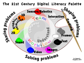
Digital Literacy
In an event as significant as the invention of the alphabet, the rapid evolution of the Web has transformed the meaning of page and thereby, literacy. Where literacy once meant the capacity to read and write combinations of words, text skill is now a subset of the larger meaning to work with combinations of all media. Where literacy is the capacity to understand and compose what goes on a paper page, a digitally literate person has the capacity to understand and compose what goes on a Web page and in Net sharable files using the full range of options that the Net and Web make available. (See graphic on the right.) To fully use Google Earth to its capacity would require the use of all elements of the Digital Palette from the strategy of its digital problem and information processing model to the methods of its currently 10 elements of digital composition.
While thinking strategically with GE is easy, the tools for composing in GE are not immediately obvious, but so well worth discovering in a "walk" across the digital palette possibilities inherent within Google Earth:
Text/HTML5.
GE provides a great deal of reading and writing through its screen displays and search box but provides a very special place for writing with its placemarks. You can learn to create your own placemark(s) and use its Info (information) box to add any text as simple text, or HTML code for links, images and much more. As noted above, one can write an entire plot sequence within a series of placemarks as a new kind of story writing (fact or fiction) while including your own text, audio, video, and images. Clicking on the placemark reveals these boxes; right clicking enables editing of the information in the placemark. Collecting and sequencing these placemarks in appropriate folders is also a kind of text composition. Placemarks with all of the edited information can be saved in a KMZ format and sent to others to open and use in GE.
Framing.
With its sidebar, timeline, placemark popup boxes, and images, GE provides a range of frames for displaying and organizing the display of multiple levels of information.
Photo/Screen Capture. If the photos layer is turned on, a giant collection of geographically GPS located images are available; it is possible to add your own photographic compositions for private or globally shared use. In addition, the built-in screen capture software within almost any operating system makes it possible to take a snapshot of any screen display and later use it slideshows and other applications.
Audio.
Recording Tours, collections of placemarks, also supports the recording/composing of audio that goes with the tour, which can also be supported with other screen recording software.
Video.
Recording video is not built-in to the free version but is with Google Earth Pro. However, using Screen Recorder software makes high quality video recording of movement on the GE screen both quick and easy in any version, including the free version.
2D animation.
If you watch the playback of a tour it is just that, a 2D animation that "hops" from one location to the next. To create a tour is to create an animation (whether in 2D or 3D mode).
3D Design.
Any zoomed in view of the Earth reveals 3D terrain, while in selected location turning on 3D buildings in Layers shows the 3D buildings (often in major cities). Use Sketchup to compose 3D buildings to be considered for placement in Google Earth; recording movement in 3D terrain for video is also easy (see Video).
Sensors/Robotics.
There is not yet a Google Earth Layer labeled sensors to find publicly available streams of sensor data though Thingful is already implementing this feature. Google is actively working towards its own approach as it published its Physical Web standard and code for the Internet of Things (IoT) in October of 2014. It is proposing at its GitHub project site that every device broadcasting data should have its own URL (Web address), and therefore be findable with a search. It is possible now however to use coding to enable mobile device GPS sensors to show the user's location in Google Earth. As for robotics, GE is not designed to control them, but the sensor data that GE will eventually provide access to may well be used to guide autonomous robots in their activities in the future.
Interaction.
Interaction is the capacity to do more than read information and for that GE provides a deep level of interaction for displaying and finding information from its search box to manipulating layers. To compose/create your own interaction from quizzes and games to special display control requires coding, options that were possible, but now with the latest version, is largely gone. It is unknown whether its prior level of interactivity will come back in some form or other.
Coding. Computer programming is readily available through its Google Earth API (Application Programming Interface) which allows 3rd party coders to add special features and make Google Earth mashups that integrate data from other applications.
This range of capacity has made GE an important example of the need for and the value of multi-literacy (Anstey & Bull, 2006; Reisland, 2005).
Closing Thoughts
Google Earth should be seen in the context of Google's mission to "organize the world's information and make it universally accessible and useful". But Google is far more than a digital search engine, library and reader. Somewhat hidden in Google's mission is an invitation built in to its tools to make, combine and share new information. Understanding begets composing. This provides endless opportunity for educators and learners of all ages to find new ways to innovate. When ready to move beyond the introductory ideas discussed here, explore GE's Showcase and Galleries as well as a range of GE provided tutorials. Such activity not only teaches how to use Google Earth but also how to extend and empower our further understanding and use of digital literacy.
 Google Earth (GE) is an extraordinary application whose features cut across almost every area of digital composition and research. Every topic has some element of geographic location to it. GE may also be the current best example of the power of integrated multimedia as GE's many features stimulate the use of all of the digital palette (Houghton, 2011).
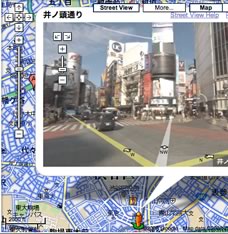 The Street View concept was initially developed for just a few cities, some 50 locations by 2008, but the international Street View list has been constantly expanding. Google keeps a constantly expanding
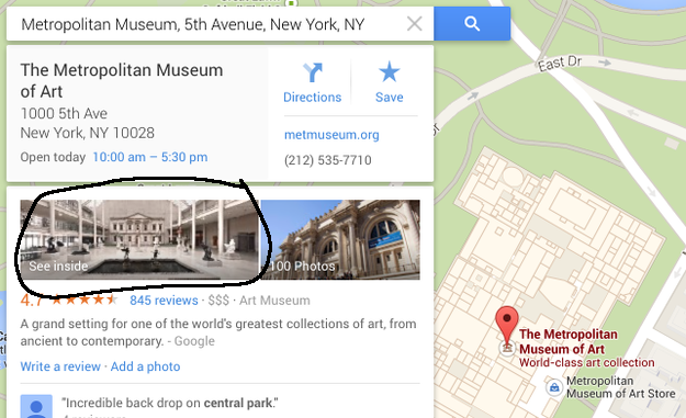
 The second graphic on the left is a montage of screen displays from Google Earth. The green-bordered box shows the screen before the Street View icon is clicked, though it is circled in this frame. The blue lines overlayed on the MET and surrounding streets show areas where Street View visuals are available when the person icon is touched. The orange bordered view shows what an inside view looks like. Drag that person icon onto the MET building and the interior views begin to appear. Just as with Street View outside buildings, use the commands for moving, rotating and zooming, which are sometimes overlayed and visible on the screen. Use the arrow keys to move around.
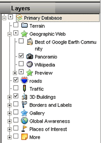 There are hundreds of kinds of layers, from the location of restaurants to a layer of pictures. To use Layers, simply add or remove checkmarks from checkboxes in front of various layer names in the Layer sidebar as shown in the graphic of this paragraph. The plus and minus signs open and close many sub-categories of additional layers. Dozens of layers of information can be super-imposed on top of each other like so many overhead acetate sheets. Some caution is required to prevent too much information from being displayed at the same time, making the map difficult or impossible to read. Clicking those layer names with plus signs in front will reveal even more information display options. However, some layer data will not appear until zooming in has gotten close enough to the surface. Scan the layer choices carefully and periodically, as new layer choices are continually being added.
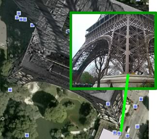 Google Earth also goes beyond map symbols to display images taken by visitors to various places or built by 3D designers. These images are uploaded images with location data. Note the small blue square with white borders in the collage of images on the left. To display photographs at various locations in Google Earth put a checkmark in front of the Panoramio option. This Panoramio layer is currently under the Geographic Web heading. Note the Panoramio checkmark in the image above. It is also possible to display 3D buildings with a checkmark. As an example, with both of these checkmarked, do a Google Earth search for the Eiffel Tower, Paris, France. Click on the picture symbols and rotate around the 3D display of the tower. In the collage picture on the above left, the bright green lines connects the blue square which was clicked to reveal that photograph within the dark green line, which was placed on top of the 3D design of the tower which has been located in its proper location on the satellite image.
 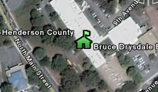 examples show the impact of creating and saving placemark files. Once clicked, the placemark links will download to the browser. Clicking any of downloaded KMZ files for these three schools will launch the Google Earth application if it is not active in computer memory and jump to the location of each school:
 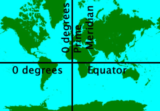 Google Earth's grid line option also makes a fine tool for understanding latitude and longitude lines.
 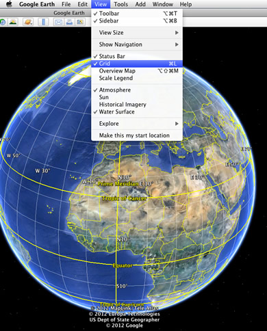 This grid system in turn provide the foundation for understanding GPS systems that are built in to GPS handheld units, phones, computers, cars and more.